RUS Remote Training for Disaster Management: Assessment of Floods and Burned Areas, November 18-19th
Save the dates for a 2-day remote training on Disaster Management, organized by UN-SPIDER, European Space Agency (RUS Copernicus) and the Systems Laboratory of the EnviSci Department at CEU!
The workshop will mark the start of the recently launched GEOHub, a research and training hub on geospatial technologies of the Open Society University Network (OSUN).
What?
The aim of the training course is to introduce students to the use of the RUS platform virtual machine to generate maps of the geographical extent of burned areas due to forest fires and floods with practical examples from recent events in Europe. It will provide the participants an opportunity to experience working with satellite images for disaster management purposes.
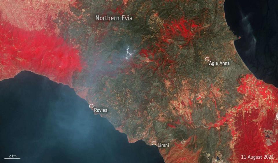
The first part of the training course will demonstrate the burned area mapping methodology on the disastrous wildfires that occurred in the northern area of the Evia Island in Greece in August 2021 and you will learn the basics of image processing using various vegetation indexes and specific band ratios such as the Normalized Burn Ratio (NBR). The Sentinel-2 MSI data that will be used with 10m spatial resolution will help us assess the severity of this disastrous event.
The second part of the training course will demonstrate the flood mapping methodology on the disastrous event that occurred in June 2021 in Rhineland-Palatinate region in Germany, and you will learn the basics of Synthetic Aperture Radar (SAR) image processing for such natural disasters, using Sentinel 1 satellite images.
This training includes hands-on exercises, where you will access from your own laptop a Virtual Machine, to exploit the open source toolboxes available in the RUS environment to download and process the data.
You can find the workshop on the website of the Office for Outer Space Affairs
UN-SPIDER Knowledge Portal here and here.
When?
The training will take place entirely online in November 18-19th and will focus on Flood mapping and Burned Area assessment.
The training will consist of one module per day (a total of 3.5-4 hours), including a 1.5 hrs demonstration, 2 hrs practical exercise together with real-time assistance from the course instructors and a live Q&A session.
What do I need?
- Students should have an interest in the potential of remote sensing techniques for disaster management. Basic knowledge GIS/remote sensing is required and experience working with GIS is desirable.
- Attendees will work on their own laptops and will be provided with access to the RUS platform Virtual Machine.
Please note that the RUS Copernicus Virtual Machines used for this training course can only be provided to citizens/residents of the Copernicus programme member countries (EU plus Iceland and Norway).
How do I apply?
The workshop will be open to international students attending education programs at the Central European University (CEU) and partners institutions of the Open Society University Network (OSUN).
Please apply here: https://forms.office.com/r/70xENYzSxh
The deadline for registration is 13 October 2021 23h59 (CEST)
Why choose us?
UN-SPIDER is the United Nations Platform for Space-based Information for Disaster Management and Emergency Response, implemented by the UN Office for Outer Space Affairs (UNOOSA). UNOOSA works to help all countries, especially developing countries, access and leverage the benefits of space to accelerate sustainable development. Since 2006, UN-SPIDER assists member states in getting access to space-based tools and data that can be used by disaster managers. UN-SPIDER has organized and facilitated capacity building events in numerous countries, mainly developing countries (see https://un-spider.org/).